 French website
  Belgian website
Holixa SMS Start
Holixa Site Management is the all-in-one data exchange and site monitoring platform that aggregates all project data crucial for progress and delivery into a single view, resulting in fewer disruptions and increased visibility to mitigate potential delays or unforeseen expenses.
Key advantages of Holixa SMS
- Improve communication and collaboration among different stakeholders
- Stay up-to-date and improve the situational awareness within the project
- Better understanding of the designs through easy and intuitive visualization
- Qualitative and quantitative site monitoring
- Quick identification of deviations, for rapid decision-making
Get everyone on site connected to the project
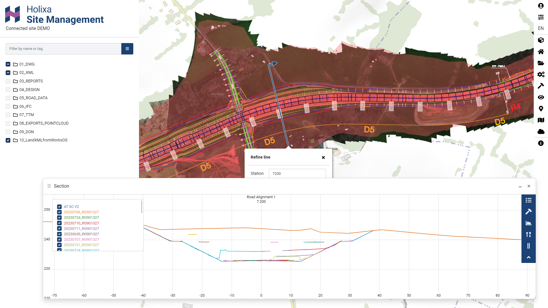
Streamline your construction project with the Starterpack. Connect all stakeholders involved, by providing not only file management of the crucial data to be exchanged, but also the necessary easy-to-use tools. The background maps provide a level of comprehensibility that is unmatched when it comes to positioning the designs or understanding an area for the first time. Easily view and review models and drawings directly on the map, as Site Management supports various file formats, including LandXML, DWG, DGN, DXF, and IFC. To increase situational awareness, add publicly available WMS and WMTS maps or your own drone imagery from the site.
Access validation tools any time on any device.
Holixa Site Management goes beyond visualization. Inspect metadata, take measurements and with a single mouse-click, open a view and gain a comprehensive understanding of the area. Cross and long section views, plan views, volume calculations, and geological data; communicate effectively via models, tasks, and views. All information needed on models and reality capture is consolidated within our platform, making it easy to follow up and track progress.
Our extensions
Starterpack is complemented with a variety of extensions and integrations.
- GeoView – Store and manage photos with for example embedded coordinates and direction.
- PointScene – Perform volume calculations based on point cloud data.
- Utilization – Track CO2 emissions of your fleet, contributing to sustainability efforts.
- Productivity – Gain detailed information about fleet operations and cycles on the construction site.
- Machine control – Seamlessly deliver design models to machine control systems.
Learn more on our extensions and integrations on the details tab…
Make your selection here:
Abonnement
Extend and integrate for data driven decision making
Starterpack is complemented with a variety of extensions.
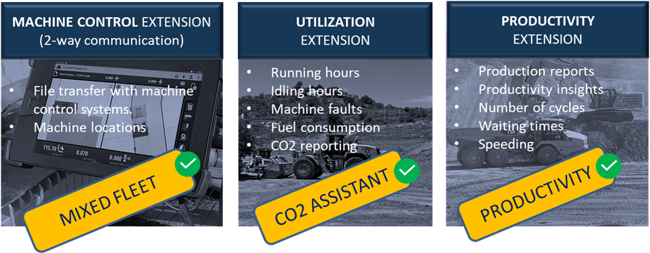
Machine Control extension is the solution to manage your mixed fleet. It enables the synchronization of data from and to machines equipped with machine control systems, provided by Novatron, Topcon and/or Trimble. The benefits of using Machine control extension are time savings, cost savings and reduced carbon footprint. These are gained by using single source file (LandXML) which is shared to different systems over the cloud connections. No need to travel or go to each machine separately with an USB-stick. Optimized monitoring of your work site and assurance that all operators are working with an up-to-date version of the design.
Do you collect point clouds and orthophotos from your construction site? This is where Pointscene integration comes to play. Orthophotos can be used in any platform that supports the WMS / WMTS map layers and combine point clouds with model information in one environment. React to unexpected changes with confidence, store up-to-date orthophotos and point clouds for instant access to project progress and precise volume calculations.
Nothing as much used as (360) pictures to quickly make report of a situation or an issue. Geoview helps you to collect and consume these captures in a structured and georeferenced way. No more time wasted to search pictures, as they are them published on location including orientation.
Ces solutions peuvent également vous intéresser


Votre logiciel
Composez votre offre
Formation
Service
Merci pour votre message
Nous vous contacterons dès que possible.
<< Retour à la page d'accueil